- Category
- Uncrewed Systems
- Date
- September 14, 2026
For four days, drones crisscrossed land and ocean north of Embry-Riddle Aeronautical University’s Daytona Beach Campus, collecting data on sea breezes.
Sea breezes are a weather phenomenon familiar to Floridians. They occur when land warms up faster than the ocean’s surface. As the hot air over the land rises, cooler ocean air rushes onshore.
During the summer, sea breezes refresh beachgoers. But sea-breeze fronts also force hot, wet air to rise, providing the lift needed to initiate powerful thunderstorms. It’s partly why Florida is a hotbed of lightning.
Matt Wilson, a scientist with the National Center for Atmospheric Research (NCAR) focused on fine-scale features within atmospheric phenomena, said predicting the weather from the sea breeze is difficult because it involves a host of minor events that are “not captured very well by forecast models.”
To help fill that gap, Embry-Riddle recently hosted a data-gathering campaign organized by ISARRA (the International Society for Atmospheric Research using Remotely Piloted Aircraft). Researchers from as far as Germany traveled to the university with a range of uncrewed aircraft systems (UAS) with various sensor technologies. They were joined by nearly 50 students from three universities — Embry-Riddle, Oklahoma State University and the University of Kentucky — who served as pilots, ground control station operators, airspace observers and members of field support teams.
Dr. Kevin Adkins, who directed the event and is a professor in Embry-Riddle’s Aeronautical Science Department as well as director of the Uncrewed Vehicle and Atmospheric Investigation Lab, said that Embry-Riddle’s UAS program prepares students with a strong technical and operational foundation. “Experiences like this give them the opportunity to put that preparation into practice while working alongside leading researchers in the field,” he said.
To capture sea breezes, teams spread across six sites and flew a dozen drones over a stretch of some 400 square kilometers, from the ocean off Marineland to west of Interstate 95. This allowed them to collect frequent, repeated atmospheric profiles to understand “very locally how the sea breeze’s strength is influenced by the variability in the surface,” said Dr. James Pinto, science deputy for the Aviation Application Program within NCAR’s Research Applications Laboratory.

Not Your Average Drones
The campaign began with an “intercomparison day,” where the researchers flew their aircraft around a 32-meter telescoping tower on a patch of coastal scrubland near the ocean. This served as a “source of truth for our meteorological sensors aboard our uncrewed aircraft,” Adkins said.
The tower holds instruments at different heights, measuring temperature, relative humidity, pressure and various winds, said Dr. Chris Roden, the engineer leading the team from NCAR’s Earth Observing Laboratory, which brought the tower to the site. Software engineer Isabel Suhr described the weather station as a “LEGO set for scientists,” capable of deploying multiple sensors across a variety of configurations.
“The observations are really accurate,” said Dr. Sebastian Hoch, a scientist with the Earth Observing Laboratory focused on atmospheric sciences. “Our limitation is that we’re at one location, so we try to pick a location that is very representative of the area.”

Drones could potentially help fill these large voids.
On the first day of the campaign, a RAAVEN (Robust Autonomous Aerial Vehicle-Endurant Nimble) drone flew overhead. The fixed-wing aircraft, which can be catapulted from the top of a vehicle to quickly collect data in storm conditions, recently played a starring role in the movie “Twisters.” On this day, it flew a methodical three-mile, back-and-forth line. With each pass, it consistently dropped in altitude.
“We’re doing transects going out over the ocean and then even reaching over to the river area,” said Dr. Melissa Wagner, associate director of science for Integrated Remote and In-Situ Sensing at the University of Colorado Boulder. “We’re really trying to see how things are changing not just horizontally but also vertically.”
The RAAVEN drone carries an infrared sensor that measures land surface temperatures. A jagged line on a nearby computer screen revealed sharp temperature differences among the roadway, scrubland and ocean.
“I'm really interested in land cover, so we’re trying to see how that may influence the sea breeze and if we can see signatures in different types of land use,” she said.

Improve Forecast Models
The troposphere is the layer of the atmosphere closest to Earth. But it’s the planetary boundary layer — the lowest layer of the troposphere — where interactions between the Earth’s surface and the atmosphere strongly influence the weather.
Observations of this layer are largely made by widely spaced weather stations, radars and balloons carrying radiosondes, which transmit data as the balloons rise into the atmosphere.
At Princess Place Preserve, a 1,500-acre parcel spreading west from the Intracoastal Waterway, Embry-Riddle students flew a drone called a “coptersonde.”
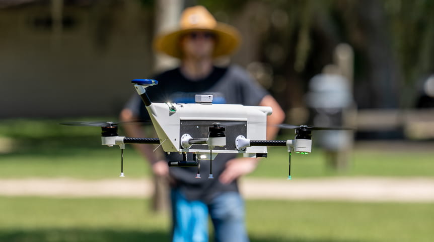
The four-rotor aircraft, developed by engineers at the University of Oklahoma, autonomously points itself into the wind, like a weathervane. Its sensors collect data on pressure, temperature and humidity, among other factors. The fast response time and sensitivity of these sensors allow for measurements “of less than one percentage point,” said Alana Dachtler, vice president of sales and marketing for InterMet Systems, which is commercializing the aircraft.
Among those piloting the drone was Oleg Sugatov, an Embry-Riddle senior majoring in Uncrewed Aircraft Systems. The student pilots are “really experienced,” Dachtler said.
The data-gathering campaign required flying above the Federal Aviation Administration’s standard 400-foot altitude limit for small UAS operations. Several teams also flew aircraft beyond the operator’s line of sight, which requires an FAA waiver to ensure airspace safety, a waiver Embry-Riddle obtained. Flying drones “beyond visual line of sight,” or BVLOS, is a critical next step in using them to collect atmospheric data.
“This is a great learning experience for [students] to see a full UAS operation,” said Jose Cabrera, assistant professor in the Aeronautical Science Department at Embry-Riddle. “These are especially complex missions, since we have multiple aircraft that are flying at once at very high altitudes.”
At a site several miles away, students from the University of Kentucky tossed three small fixed-wing drones into the air.

Several Embry-Riddle students collaborated on the operation, serving as visual and electronic observers, handling battery management and monitoring nearby aircraft.
“They come with a whole wealth of expertise that we've been able to tap into,” said Dr. Sean Bailey, a professor of mechanical and aerospace engineering at the University of Kentucky.
With the University of Kentucky’s drones approaching Princess Place Preserve from the west and the RAAVEN drone approaching from the east, as well as additional uncrewed aircraft systems capturing other data, a “dense profiling network” was created, said Pinto, the senior NCAR scientist.

The high-resolution sea breeze data collected during the flight campaign will later be studied, Pinto said, to see if weather models can be improved.
In the future, feeding such observations into real-time models could help forecasters better predict the sea breeze — keeping people safe from severe storms and lightning bolts.
Related News